Standard media reporting treats consecutive seismic events as isolated, sensationalized incidents. When a magnitude 6.2 earthquake struck off the coast of Davao Oriental, Mindanao, at 5:18 pm local time on June 15, 2026, outlets frames it as a second independent "jolt" following the catastrophic magnitude 7.8 mainshock on June 8. This represents a fundamental misunderstanding of lithospheric mechanics.
Geological systems do not operate on a clean news cycle. To understand the true vulnerability of the southern Philippines, analysts must abandon superficial metrics and deconstruct the operational, structural, and geological reality of a prolonged seismic sequence.
The Structural Mechanics of a Complex Forearc System
Mindanao does not sit on a single plate boundary; it is an active collision zone crushed between two opposing subduction zones. To the east lies the Philippine Trench, and to the south and west sits the Cotabato Trench system. The June 8 mainshock—a massive magnitude 7.8 thrust faulting event—was generated directly along the Cotabato Trench, where the Celebes Sea basin subducts beneath the Mindanao volcanic arc.
The structural failure of this zone follows a predictable stress-transfer mechanism. When a fault ruptures during a major earthquake, it does not relieve all regional stress; it transfers the load. This phenomenon is defined by three specific phases:
- Co-seismic Rupture: The initial slip on the main fault plane. In the June 8 event, this slip was massive enough to deform the local geography, forcing parts of the seabed upward by two meters (6.6 feet), displacing subsea coral, and extending shorelines by up to 200 meters.
- Static Stress Transfer: The permanent changes in the surrounding rock crust's stress field caused by the displacement. The massive friction along the Cotabato Trench loaded neighboring fault fragments to their failure thresholds.
- Dynamic Stress Triggering: The passage of seismic waves through adjacent, already stressed structures, pushing unstable systems into immediate failure.
The June 15 magnitude 6.2 event was not a new earthquake. It was a high-magnitude aftershock, one of more than 2,100 recorded within a single week. However, its specific location off the coast of Mindanao at a depth of 112 kilometers introduces a critical structural variable: depth attenuation.
A depth of 112 kilometers places the hypocenter (the exact point of origin inside the earth) deep within the subducting lithospheric slab. Deep earthquakes distribute kinetic energy over a vastly wider geographical area, but the energy attenuates—meaning it loses intensity—before reaching the surface. This is why the magnitude 6.2 event caused no immediate surface casualties or localized tsunamis, distinct from the shallower, highly destructive sub-surface ruptures of the prior week.
The Cost Function of Cascading Geo-Hazards
The initial media focus on a major earthquake invariably zeros in on structural collapse within urban cores, such as General Santos City. This view ignores the primary driver of mortality in topographically steep tropical regions: earthquake-induced landslides.
Data from the national disaster agencies and high-resolution satellite imagery (including Sentinel-2 observations from June 14) confirm that out of 65 confirmed fatalities from the initial June 8 mainshock, more than half were caused by mass wasting events (landslides). With 36 individuals still missing beneath deep mountain collapses, the projected final mortality rate reveals that terrain failure outpaced structural building failure as the primary threat to life.
The susceptibility of southern Mindanao to these cascading failures is governed by a strict physical cost function consisting of three variables:
- Slope Gradient and Geometry: The steep, young topography of provinces like Sarangani, South Cotabato, and Davao Occidental is inherently unstable.
- Pre-Existing Structural Degradation: The region is sliced by the Philippine Fault Zone and local thrust sheets, leaving the bedrock fractured and weak.
- The Saturation Index: High seasonal tropical rainfall fills porous soils, elevating pore-water pressure and reducing the friction holding hillsides together.
When the magnitude 7.8 mainshock delivered high peak ground acceleration across Mindanao, it instantly triggered at least 66 major damaging landslides. Whole mountainsides collapsed into remote valleys. This creates a severe operational bottleneck. The remote geographic footprint of these landslides isolates rural communities, blocking heavy machinery and shifting search-and-rescue timelines into slower, less effective recovery operations.
The Compounding Vulnerability of Built Infrastructure
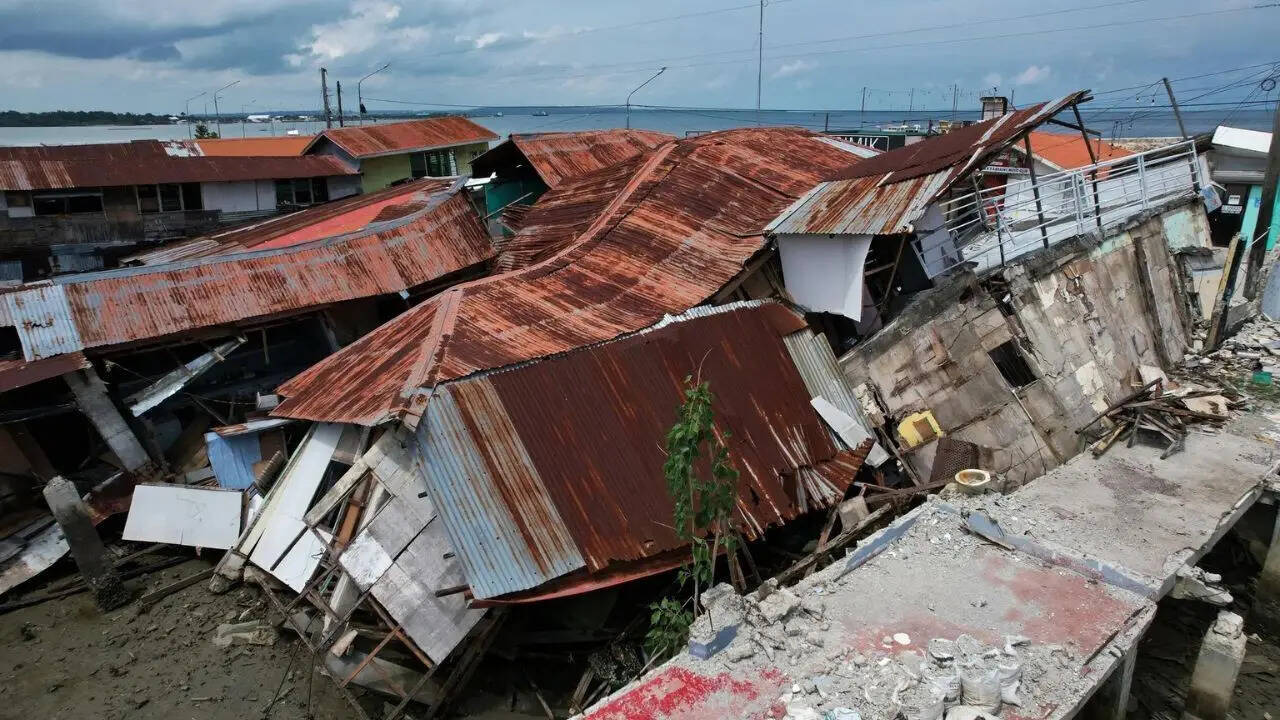
The secondary threat of high-magnitude aftershocks, like the June 15 event, lies in their interaction with already compromised infrastructure. Civil infrastructure subjected to a magnitude 7.8 earthquake undergoes severe material fatigue and structural deformation, even if it remains standing.
A major structural vulnerability in southern Mindanao stems from regional economic factors and code enforcement limits. Urban centers feature modern reinforced concrete, but rural and semi-urban perimeters rely heavily on non-ductile concrete frames and unreinforced masonry. These materials possess low tensile strength, meaning they cannot bend or flex under stress without breaking.
During the initial mainshock, more than 3,100 homes, along with critical bridges, roads, and government buildings, sustained heavy structural damage. This creates a state of accumulated structural degradation.
The threat of a subsequent magnitude 6.2 aftershock is not that it will generate new destructive forces, but that it targets structures with zero remaining structural reserve capacity. A building with cracked load-bearing columns or a bridge with sheared support pins can easily collapse under minor secondary vibrations.
This risk extends to critical transit infrastructure. The suspension of operations at General Santos International Airport and the physical cracking of arterial highways during the mainshock directly crippled the supply chain for emergency responses. When aftershocks strike a disrupted logistics network, they delay engineering inspections, stall concrete curing for emergency repairs, and leave vulnerable populations isolated for longer periods.
Operational Realities of Co-Seismic Mitigation
Effective disaster mitigation in a high-frequency seismic zone requires precise risk management, not panicked reactions. Following an offshore event like the June 15 aftershock, local provincial disaster offices must immediately execute a strict dual-track assessment protocol.
The primary track is tsunami verification. Because the aftershock occurred at a depth of 112 kilometers, displacement of the column of water above it was highly unlikely. However, local disaster teams must actively monitor coastal shorelines for rapid, abnormal water recession—the classic indicator of an impending tsunami wave train.
The second track requires a systematic review of structural integrity across the region. Mitigation teams operate under severe constraints, balancing immediate rescue risks against long-term community recovery.
- Dynamic Exclusion Zones: Disaster managers must map active landslide scars and establish strict exclusion zones. Ongoing aftershocks can easily destabilize loose debris fields, triggering secondary slides onto rescue teams.
- Rapid Structural Triage: Engineers must deploy immediate visual tagging systems (Green for safe, Yellow for restricted access, Red for unsafe) to prevent civilians from re-entering weakened homes before aftershocks subside.
- Resilience Investment Realities: Long-term risk reduction demands replacing old masonry with flexible, lightweight timber structures or high-ductile reinforced frames in high-risk zones. However, funding limits and local economic pressures mean these structural upgrades happen slowly, leaving communities exposed to the ongoing seismic sequence.
The seismic sequence across Mindanao highlights a clear geological truth. The region will face ongoing, high-magnitude aftershocks for weeks, if not months, as the Cotabato Trench system slowly finds a new mechanical equilibrium.
Failing to recognize these events as part of a single, interconnected geological process guarantees that infrastructure planning and emergency responses will remain reactive, inefficient, and exposed to the next major fracture.